
There is also a piece of land between the mountain ranges around the world, which is called “Plateau” or plateau. Here, plateau refers to a high land area. In geological sciences, it is also called Table Land, because due to its spot surface and height, it resembles a “table”, but the mountain also seems to touch the height of the sky.
Therefore, it is important to determine the difference between the two. The difference between a mountain and a plateau is that if the mountain is not horizontal, but curved, then there is an angular slope in both its arms, which go up and merge with each other to form a “crest”, which is the height of any mountain. It is the uppermost part, the area of which is much less than its lower surface.
It rises at least 2000 feet and at most thousands of feet above its surrounding areas. For example, the Himalayas and the Karakorams, while the plateaus do not have a limb. For this reason, the slope angle has been found to be zero degrees or sometimes up to 10 degrees in some places which is listed as horizontal rocks. The upper part of the “plateau” is much wider and spotty (like a football field) than the lower parts.
As if a “plateau” is a mountainous plain surrounded by rugged mountains. Its height from sea level reaches several hundred feet and at most thousands of feet, but the sides of the plateau below the highest mountain have springs, rivers and fertile soil that are no less than a boon for life and regeneration. no.
Field survey and chemical and physical analysis of ancient created plateau around the world reveals that it is the result of two natural factors namely “volcanism” and “mountain building”. As for the volcanism, it started 200 million years ago when the Rifting Power gave birth to the Atlantic Ocean.
Over time, a large rift occurred in the middle of the Atlantic Ocean, through which the “Midashonic Range” (undersea mountain range) was formed, under which the Rift Valley was created. Aya, who laid the foundation of the volcano by separating the rock layers above the earth (barri and bahri) from each other, while in some parts of the interior of the earth, these rock layers come closer and closer together and cause collision. became and the process of mountain building came into being.
It should be remembered that the rock layers that exist at a depth of 100 km underground are not a rock unit, but they resemble a solid mobile slab, with fissured edges. Which are just like the cracks in the shell of a boiling egg due to the intensity of the heat.
In this way, during the process of differentiation, the margins of the rocky plate became rifted, providing the basis for seafloor spreading and land collision, from which molten rock material (basaltic magma) erupted in the form of volcanoes under the influence of geothermal energy. , after freezing an ancient layered volcanic rock (basalt) spread over vast areas.
This continued around the ocean and land floor, setting the stage for prehistoric and juvenile volcanism, which created the “plateau” or plateau. For example, Columbia Plateau in the west of Idaho Mountain, Deccan Plateau in India, Colorado Plateau in America, Potohar and Balochistan Plateau in Pakistan and Tibet Plateau in the foothills of Himalayas.
As for the Idaho-Columbia Plateau, it is the most extensive and spotty lava plateau in the world. It includes territories in Washington, Oregon, California, and India. From here the basaltic lava flowed out of the fissure, and over an area of at least 20,000 square miles, the mojo spread like a flood around the ancient rocks. The maximum depth when frozen was found to be about 5000 feet while the temperature of the lava was 1000-1200 degrees Celsius. Some rocks that got in the way of the lava were buried under it. Parts of the mountains in the ancient nearby Snake River valley have been exposed due to river erosion.
On the wall of the trenches in this “plateau” there is a layer of columnar basaltic lava indicating volcanism. This type of lava spread is known as “Deccan Plateau” in India which consists of molten rock material “basalt” representing the ancient fragments of Josmundry floor. This is called “Ophiolite”.
The eruption of lava here occurred during the Upper Cretaceous period of the geologic time scale, covering an area of 518,000 square kilometers. The maximum thickness of this plateau is 2350 m near the coast of Mumbai, while its thickness decreases towards the east.
The plateau appears to be almost spot-level, but has been measured as much as 10 degrees in some places. In some geological ages, instead of volcanism, the process of “mountain building” arose. This occurs when rock plates collide instead of rifting, which is a sign of “mountain building”, resulting in faults and folds. For example, the “Colorado Plateau” has come into existence in the past based on this type of activity, which is spread over 13,000 square miles, showing uplift under a strong force. It has a vertical fault trend, especially in the southwest or “Grand Canyon” section.
The rocks present in this “plateau” represent different geological periods and appear to have been transformed into deep trenches or troughs (through which the river flows) as a result of repeated uplift and erosion. Here the “Colorado” River is a spectacular “Grand Canyon” canyon that is 7500-9800 feet high. This plateau is the “pedemount” plateau, which refers to the base of the rock because the plateau is formed at the base of the rocks and then reaches the sea.
There are several “plateaus” in Pakistan, one of which is the “Pothohar” and the other is the Balochistan Plateau. As far as the “Potohar” Plateau is concerned, it is surrounded by the Jhelum River in the East, the Indus River in the West, the Kalachata Mountains in the North, while the southern part of the Plateau is covered by the Thal Desert. This 5000 square mile plateau is 1200-1900 feet above sea level.
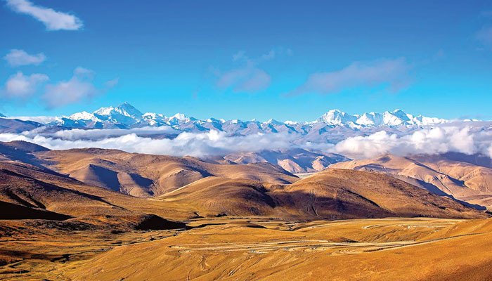
The Koh Namak range is the highest mountain in the area through which the Jhelum River passes. While the average height of Balochistan Plateau is around 600 meters above sea level. This plateau is located southwest of Mount Solomon and west of Mount Kirthar. It is underlain by two faults due to tectonic collision. That is, “Chaman fault” and “Ornach fault”. This fault runs from north to south from Chaman to the Arabian Sea, which confirms the process of mountain building, but the highest “plateau” on earth is at the foot of the Himalayas. I have the “Tibet Plateau”. It is of the “Intermountain” style.
That is, the mojo spot field in the middle of the rocks, which is 1200 feet high, shows its creative affinity, while the younger rocks around other plateaus, such as the African Plateau, are not mojo, which reveals the fact that it is They have come into being only through upliftment. It is also called the “roof of the world” because it is higher than all the plateaus in the world.
From the economic point of view, the “plateau” regions are called “storehouses” in terms of mineral resources, because mining activities are taking place all over the world in such plateau regions. For example, the African Plateau has proven to be very beneficial for gold and diamond mining. Significant oil reserves have been discovered in the Plateau region in Pakistan as well. In 1915, at the location of “Khar”, Dhilian in 1955, while in 1968, a major oil discovery was made around “Toot”, while drilling has been going on in Pothohar since 1970. It is also being used for agriculture, animal husbandry, lion farm and hydroelectricity.