
Prehistoric man thought that only 28 percent of the Earth’s surface had natural features, while the remaining 72 percent contained an inexhaustible supply of salty ocean water. , the most important reason for which was the backwardness of scientific consciousness, but with the modern scientific discovery, today’s developed man is also surprised to know that the mountain ranges within the sea are spread to a long area where earthquakes and earthquakes occur from time to time. Hydrovolcanism also tends to level off, causing mountain ranges to rupture, allowing superheated “terrestrial fluids” such as magma and lava to flow onto the ocean floor.
The most surprising thing is that in these high thermal areas, life and regeneration activities continue close to some valuable deposits and special thermal attractions, but the sea water is very deep (900-4000 meters). Because no part of these areas is exposed to the sea. For this reason, until 1873, experts were unaware of their condition. After the Second World War, the ship named “Challenger” was equipped with modern equipment and wandered in search and discovery of the invisible world, which resulted in the first time the basis of echo sounding technology. But the world became aware of the amazing information about the true structure and profile of the underwater sea floor, which made the ocean an international focus and center of research and analysis.
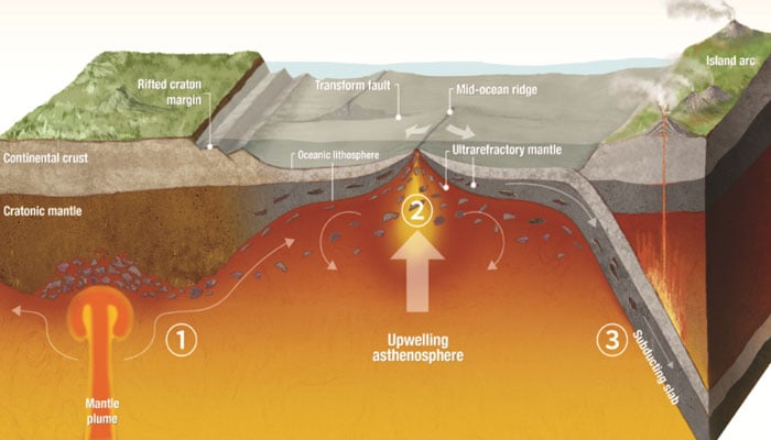
As a result, 66 countries united to explore the mysterious world of the ocean, diving to the depths, collectively revealing that there is a great mountain system in the middle of the “Atlantic” ocean, from which hot fluid material. Continually boiling out and joining the seawater, causing the formation of new seafloor (crust) as well as the release and freezing of “terrestrial fluids” on the seafloor, i.e. magma and lava. Great mountain ranges are also forming, which have their own “crest”. Scientific circles unanimously suggested its name as “Mid-oceanic Ridge” in geological terms.
These ridges are generally made of igneous rocks and are estimated to be about 80,000 km long and 1,500-2,500 km wide. A valley system has also been found in this “Mid-Oceanic Ridge”. It is called a “Rift Valley” sequence which is a link of the stress-strain sequence which is connected to the normal fault on both sides. The creation of a rift valley on the crest of the “Mid-Oceanic Ridge” represents a surprising feature, as there is no mountain range on Earth where such a valley travels along the crust.
The presence of this kind of surprising differential valley is created either in the places of the continent where two plates are moving away from each other (Divergent of Plate) or on the other hand in the areas where “Mid-Oceanic” Raj” dominates. They are like sharp daggers quite different from the valleys on Earth, the most classic and developed example of which is the Mid-Atlantic Ridge.
The “Mid Ridge” stretches 10,000 miles along the central Atlantic and dominates three parts of the seafloor that are the epitome of tectonic force. Its summits are higher (submerged) than mountain ranges on the continent, but occasionally rise above sea level in the form of islands. For example, the island “Mount Pico” in the Azores, Portugal. Taking into account all this information, in 1974, the foundation stone of a project like the “French-American Oceanic Underwater Study” was laid, the objectives of which were to study the Mid-Ridge directly underwater, its images stored in camera. Karna and prioritizing the acquisition of various rock artefacts were included.
Geologists collected very clear evidence through this project, which concluded that there is definitely a “differential valley” around the “Mid Ridge”, with a fine line of cracks running parallel to it. is the result of the expansion of the fault. These fine fissures are visible in some places in the form of fissures, on one side of which present-day “Pillow Basalt” is present in the form of a narrow band on the floor of the rift valley, representing recent volcanic activity. does. Experts seem to agree that the rift valley in the “mid-ridge” indicates continuous and sometimes submerged volcanism and natural factors such as earthquakes associated with differential forcing.
On the other side there is a row of hot springs which are also undergoing precipitation as well as metal bearing. Experts from the diving profession have directly observed the presence of hot springs in several places in these valleys in the Mid-Ridge and attributed the presence of these hot springs to the high temperature emitted from the shallow basaltic magma, which is 20 degrees. Celsius to 350 degrees Celsius. As the warm water escapes from the upper side of the rift valley and rises, the cold water from the fringes advances to take its place.
Thus begins a cyclical process, during which cold ocean water flows through basaltic cracks associated with the underlying ridge and reappears on the seafloor. It has also been observed during the underwater survey that the rift valley at the “Mid Ridge” is associated with the rift zone in many places, causing the sea floor to be lower and higher in some places. Where steep cliffs are clearly present. The rift valleys that exist at this point are connected by faults.
These are called “transform faults” that extend several thousand kilometers across the ocean floor and eventually converge towards the continental margin. Sea mounts are found at some places on the sea floor, which are conical underwater mountain peaks. Some of it is exposed above sea level in the form of islands. They are found scattered on the arms of the mid-ridge.
Some areas of the ocean floor have very large concentrations (about 10,000) of sea bream in the western Pacific. Rock samples obtained from Bahri Peak have been found to contain basalt igneous material, thus confirming that most Bahri Peaks are inactive volcanoes. Few of them are active and most of them are formed in the crust of the “Mid Ridge”, although two volcanoes appear to be active around these areas, but they are located on the island of Hawaii and are not connected to the ridge. .
Some sea crests also go through the process of undersea erosion, due to which the upper part which is conical becomes spotted (behind the waves) due to the process of erosion and goes under water. It is called Guyots. These spot-roofed gyhuts have moved several hundreds of meters below sea level, causing “subsidence”. After collecting dead coral samples from its top, there is evidence that these coral reefs thrive only in shallow water. Can be found at the depth of the current position when submerged. Many seamounts and geysets occur in series on the sea floor.
These igneous series and other ridges join on the seafloor to form a ridge that is submerged but not associated with earthquakes. All of the igneous activity occurred in areas bounded by islands, which in some places appear to have been deeply struck, leading to deep trenches formed by the faults that surround them. A fiery performance is taking place. The largest trench discovered in the Pacific Ocean is called the Mariana Trench.
It appears plunged about 7 miles below the sea. Other deep trenches have been identified off the coast of Japan, the Philippines, Java, western Mexico off the coast of Peru and Chile. All these trenches are known to be about 6 miles deep and 2000 miles long. Around these trenches there are small active volcanoes which are also releasing valuable minerals and metals. These volcanoes, which usually look like chimneys, form in places that completely cover the “ridge” trenches. These are “Black Smoker”.